Links: Previous
map for Jaws -- Next map for Jaws
Maps for Bunga -- Maps for Elsie
-- Maps for Bluebeard -- Maps for Tasha
Birds
of Prey page -- Osprey
main page -- Migration
page -- Home
Page
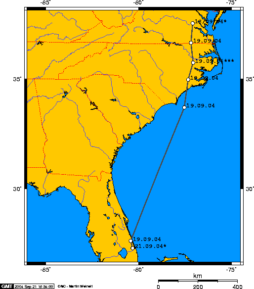 |
21 Sept: Jaws definitely
hitched a ride on the strong northerly winds. We knew there was something fishy
(appropriately enough for an Osprey) with the timing of our satellite
locations. If the dates and times on this last set of data were to be
believed, Jaws flew 655 miles (1055km) in a bit over 6 hours! In fact, the
last four locations all had the same time. Now I know
there were some strong tail winds, but that's ridiculous. We do know that
his locations are correct--based on the last location here, the BBC crew tracked him down around midnight
on the 20th at his roost site. (He was gone when they got there in the
morning, of course.) As it turns out, the first location on the Florida coast was really on the 20th at about 4PM. The first location over the Atlantic, SE of Baldhead Island, was about 25 hours earlier. We don't know where he hit the Florida shore, because there's a big gap in our data. The whole trip on this map is about 650 miles, and the time between fixes is 35 hours. This would give him a ground speed of 18 mph, which is a bit slow, especially with a tail wind. So it's a good bet he hit the coast somewhere up the Florida coast early on the 20th, worked his way south, and spent the night of the 20th between Lake Okeechobee and Stuart, FL.
|
Birds of Prey page -- Osprey main page -- Migration page -- Home Page